Over the last couple months, I had the privilege of connecting with neighbours at events across the region, to introduce the One Million Neighbours vision document and have conversations about priorities in their neighbourhoods.
- In late July, we attended the Rhythm & Blues Emancipation Day event in Soper Park in Cambridge. Commemorating the end of slavery in the British Empire, this event celebrated diverse Black communities with song, dance, food, and art. We collected ideas in our Neighbourhood Wish Box, which will help us connect neighbours who could work on projects together!
- On September 13th, we attended Creekfest, celebrating the Schneider Creek and shining a spotlight on an under-recognized part of our watershed. The event took place on Old Mill Road in Kitchener’s Doon neighbourhood.
- On September 14th, I led a Food Systems Mapping workshop for the Nourish the Neighbours event in the Mary Allen neighbourhood, near uptown Waterloo. We collectively mapped the assets of our food system — not only places to buy groceries, but also informal gardens, foraging locations, picnic spots, and reflections on how food is integrated in our cultural traditions.

RSVP for Multisolving book discussion on October 10th
I want to extend an enthusiastic invitation to anyone that has attended our roundtable discussions — join fellow leaders from grassroots, non-profit, and governmental organizations to learn from one another and discuss the “multisolving” approach to addressing complex problems.
Presented by One Million Neighbours WR, the Laurier Centre for Sustainable Food Systems, Social Development Centre WR, and Festival of Neighbourhoods, this event is an interactive discussion with Dr. Elizabeth Sawin, author of “Multisolving: Creating Systems Change in a Fractured World”.
The event is happening on October 10th, between 3-5pm. Please RSVP on Eventbrite.

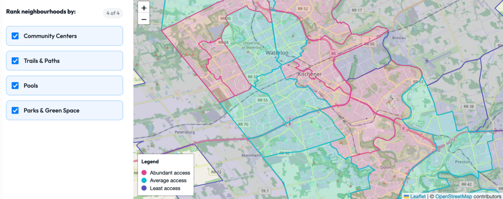
Building a Neighbourhood Equity Map with CivicTechWR
Working with volunteer software developers from CivicTechWR, we built an advocacy tool called the Neighbourhood Equity Map. This map is a proof of concept showing different neighbourhoods’ level of access to parks, pools, trails, and community centres. Which neighbourhoods have abundant access? Which ones need more investment in public space?
We still have some work to do to ensure data accuracy before releasing the map publicly, but we intend to continue adding information about which services and resources are accessible throughout the region in order to make the Neighbourhood Equity Map a valuable advocacy tool.